India Venster – High-Altitude Rock Window and Thrilling Mountain Adventure
- Brigitta Kukely
- Aug 17, 2025
- 7 min read

Updated: Aug 21, 2025
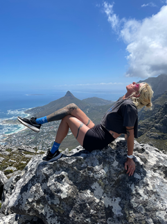
My favorite hike around Table Mountain was definitely the India Venster. It was a truly exciting and quite challenging hike, but every moment of the effort was worth it. The route offered cliff faces, steep ascents, and breathtaking panoramas for adventure seekers. In addition, I managed to explore a few other trails in the area, making each day full of new discoveries and unforgettable experiences.
India Venster – A Breathtaking Hike to the Drakensberg Rock Window
India Venster is one of the most famous and stunning viewpoints in the Drakensberg Mountains of South Africa. The word 'Venster' means 'window' in Dutch/Afrikaans, and it’s no coincidence: the rock window offers a breathtaking panorama of the surrounding mountain ranges and valleys.

Trailhead
The hike begins at the Sentinel Car Park, which is easily accessible from the Royal Natal National Park. Even the first section, leading to the Tugela Gorge, is impressive: hikers are accompanied by towering cliffs, lush valleys, and flowing streams.
The Route
The hike is moderately difficult, with some sections requiring steep rock climbing, so a good level of physical fitness is necessary. Upon reaching the Amphitheatre Plateau, the view already hints at what awaits at India Venster. The rock window itself presents a unique challenge: it’s important to cross it with stable footing and careful steps, while the surrounding mountain panoramas are simply breathtaking.
Hiking Tips
Start early in the morning to ensure you have enough time to return in daylight. Alternatively, you can take the cable car down at the end. That’s what we chose. :)
Wear sturdy boots with good grip and dress in layers. It can be chilly on the mountain, and the rocks may be slippery.
Bring enough water and energy bars, as the hike can be several hours long and tiring.
If you’re a beginner, it’s a good idea to hire a local guide who knows the steep rocky sections, or go with someone familiar with the route.
Why is it worth it?
The India Venster hike is unforgettable not only because of the challenge. The stunning nature of the mountains, the rocky panoramas, and the closeness to the wilderness make every moment worthwhile. Whether you are an experienced hiker or simply a nature lover seeking adventure, this trail is guaranteed to provide a once-in-a-lifetime experience.
Lion’s Head – Airy Panorama Above Cape Town
Lion’s Head is one of Cape Town’s iconic mountains, rising above the city and the Atlantic Ocean, and offering a fantastic 360° panorama of Table Mountain, the city, and the sea. The mountain got its name from its shape: from the side, the peak resembles the head of a lion.

Trailhead
The hike begins near the Signal Hill/Lion’s Head parking area, where the trailhead is easily accessible. The hike is relatively short but intense, and can be completed in half a day. I finished it in about two and a half hours (round trip).
The Route
The trail is of medium difficulty, gradually ascending along rocky paths. In some sections, chains and ladders assist with the climb, especially near the summit. The hike is particularly popular in the early morning and evening hours, when the sunrise and sunset beautifully illuminate the city and the surrounding mountains. There were almost always many people on the trail, no matter the time of day
Hiking Tips
Early Start: Sunrise is ideal, with fewer tourists and beautiful lighting.
Safety: On the rocky sections, move carefully step by step, and wear proper footwear.
Gear: Bring water, sunscreen, a hat, and some energy bars.
Photography: The photos taken at the summit are breathtaking, with the city, Table Mountain, and the Atlantic Ocean all visible at once.
Why is it worth it?
Thanks to its short length and easy accessibility, the Lion’s Head hike is ideal for those who want to enjoy fantastic views in a short amount of time. The panorama from the summit is both calming and exciting, offering perfect photo opportunities. I took my best pictures here.
Platteklip Gorge – The Easiest Route to the Top of Table Mountain
Platteklip Gorge is one of the most well-known and fastest hiking routes up Table Mountain in Cape Town. Although it is relatively steep, its well-maintained trail allows anyone to safely reach the top of the mountain and enjoy the breathtaking panorama.
Trailhead
The route begins next to the lower station of the Table Mountain Aerial Cableway. The trailhead is easily accessible by car or public transport, and the path is well marked.
The Route
The hike is of medium difficulty: the trail ascends continuously, but there are no technically challenging rocky sections. Despite the steep incline, stone steps and handholds built into the rocks help with the climb. Along the way, there are fantastic views of Cape Town, Lion’s Head, and the bays surrounding the city.
Duration: approx. 2–3 hours up, about 1.5–2 hours down
Distance: approx. 3.5 km one way
Elevation gain: approx. 700 meters
Hiking Tips
Ideal for beginners and families, as the trail is well-marked and stable.
Start early to avoid the crowds and the afternoon heat.
Gear: comfortable hiking boots, water, hat, and sunscreen.
Safety: be cautious on slippery rocky sections, especially in rainy weather."
Skeleton Gorge – A Shaded Trail on the Green Side of Table Mountain
Skeleton Gorge is one of the most exciting and lush trails on Table Mountain, starting from Kirstenbosch Botanical Garden and ascending to the summit via a steep, shaded path. Along the hike, streams, waterfalls, and dense forest await, offering an experience completely different from the city trails.

Trailhead
The trail begins at the entrance of Kirstenbosch National Botanical Garden. The trailhead is easily accessible by car or public transport, and a well-marked path leads up into the mountains.
The Route
The hike is of medium to difficult level: the trail ascends steeply, with rocky sections assisted by chains and handholds. The path, shaded by forest and running alongside streams, offers the lush beauty of nature rather than city views. Along the way, there are fantastic vistas of the mountain range and the green side of Table Mountain.

Duration: approximately 3–4 hours uphill, 2–3 hours downhill
Distance: about 5 km one way
Elevation gain: approximately 700–800 meters
Hiking Tips
Start early to avoid the crowds and the hottest hours. Fortunately, the trail passes through shaded areas.
Bring water, energy bars, and sturdy boots with good grip.
Be careful on slippery rocky sections, especially in rainy weather.
Take photos near the streams and forested sections – the contrast with the mountain panorama is stunning.
Why it’s worth it??
The Skeleton Gorge hike is recommended for those who want to immerse themselves deeply in nature and enjoy the green, shaded side of Table Mountain. Although the trail is steep and physically challenging, the lush forest, streams, and waterfalls make every step worthwhile, offering a unique and memorable experience for explorers of the mountain.
Kasteelspoort – The Steep, Wild Trail to Table Mountain’s Summit
Kasteelspoort is one of Table Mountain’s classic, historic hiking routes, offering an advanced challenge for those who enjoy steep, rocky terrain and less-traveled paths. The hike begins in the valley and ascends between the mountain’s impressive cliffs, rewarding hikers at the summit with breathtaking panoramic views of the city and the Atlantic Ocean.

Trailhead
The trail begins at the Kasteelspoort entrance, which is easily accessible by car or public transport. The starting point features a well-marked path, but hikers should be prepared for steep and rocky sections, especially if they are beginners.
The Route
The hike is tough!
I didn’t die from it, but it was definitely a challenge.
The trail starts with a steep ascent, then continues through rocky sections aided by handholds and steps, leading up into the mountains.
Duration: approximately 3–4 hours uphill, 2–3 hours downhill
Distance: about 4–5 km one way
Elevation gain: approximately 700–800 meters
Hiking Tips
Not recommended for beginners; suitable only for experienced hikers or those in good physical condition.
Bring water, energy bars, sturdy hiking boots with good grip, and trekking poles can help with stability.
Be cautious on steep, rocky sections, especially in wet conditions.
Start early to avoid the heat.
Why It’s Worth It?
The Kasteelspoort hike is perfect for those seeking a challenge and wanting to explore the wilder, less-visited side of Table Mountain. While physically demanding, the rocky trails and the mountain’s majestic panoramas make every effort worthwhile, offering an unforgettable experience for climbers and nature enthusiasts alike.
I could talk about countless hikes, but these routes truly stand out. If any of them caught your interest, feel free to ask, and I’d be happy to share more detailed stories about it. :)


Here’s a +1 secret gem for Table Mountain lovers: Hout Bay’s Karbonkelberg Trail.
The Karbonkelberg Trail is a lesser-known, scenic hike near Hout Bay, offering panoramic views of the Atlantic Ocean, Hout Bay itself, and the surrounding Sentinel cliffs. The trail winds through rugged, rocky terrain and pristine fynbos, making it perfect for hikers seeking a quiet, adventurous escape.
Trailhead
The hike starts from the Karbonkelberg car park near Hout Bay. The trailhead is easily accessible by car, and there’s limited parking at the base. The path is well-marked but expect rocky and sometimes steep terrain.
Route
The trail is moderate to challenging:
Terrain: Rocky paths, occasional steep climbs, and narrow sections along cliff edges.
Highlights: Secluded beaches, panoramic ocean views, and untouched fynbos.
End point: Many hikers turn around at the viewpoint overlooking Hout Bay and the Sentinel cliffs, though experienced hikers can continue along the ridge.
Distance: ~6 km round trip
Elevation gain: ~400–500 m
Duration: ~2.5–3.5 hours
Hiking Tips
Start early to avoid the heat and enjoy the morning light over the bay.
Footwear: Sturdy boots with good grip are essential for rocky and uneven sections.
Supplies: Bring water, snacks, sunscreen, and a hat.
Safety: Watch your footing along the cliff edges; sections can be exposed and slippery when wet.
Photography: The viewpoints offer amazing shots of Hout Bay, the Sentinel, and the Atlantic Ocean.
Why It’s Worth It?
The Karbonkelberg Trail is a quiet, scenic alternative to the crowded Table Mountain routes. It rewards hikers with dramatic coastal views, rugged terrain, and a sense of solitude. Perfect for those who want a mix of adventure and nature, away from the tourist crowds.


Comments